Reasons to see North Dakota in the fall, photo safari — Evening gold Pt 1.

sunflower-gravel-road-and-golden-hour-sig-small

Domesticated sunflowers never rotate with the sun unlike their natural cousins that follow the sun. That’s why this mature field of sunflowers face east with the sun at their back. (One reason I like this photo, besides the leading lines is the hot/cold contrast of ground color and sky color.)

This fall, I’ve taken to exploring the last hour of the day with camera and dog.  That’s  easy to do because the golden hour is actually pretty early these autumn days; the colors are warm and the contrasting light is illuminating.  The golden hour, the golden sunset and the golden colors are striking.

mike-gunnar-sunset-prairie

Gunnar the foster dog leaps through tall prairie grasses on our walks. The golden grass, yellow skies and his yellow fur compliment each other

About 4:00 or so, the dog gets pretty alert and by 5:00, he’s ready to go.   He’ll pace back and forth or stand by the back door until I am ready.  Then he gets to the truck to wait for me, and off we go to find an abandoned section line road to explore.

eight-wind-turbines

Even just eight wind turbines disrupt the horizon. Imagine what 105 turbines do to the landscape.

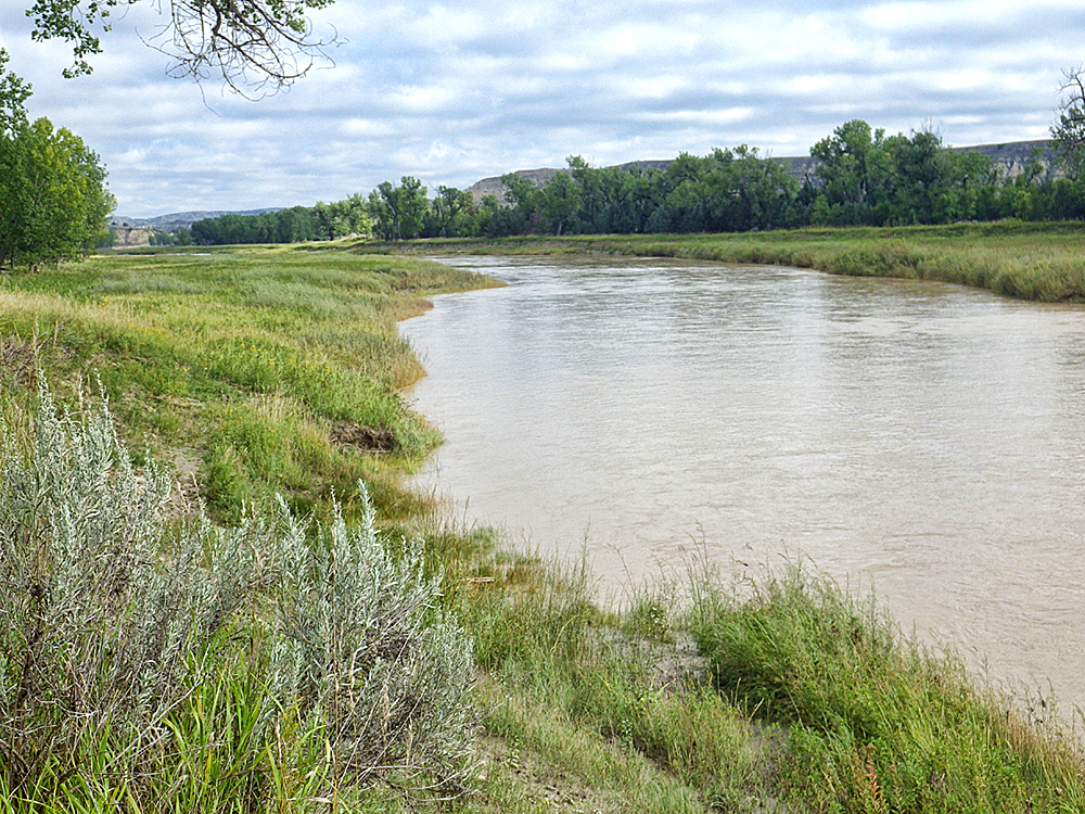
Up until about 8 years ago, there were more opportunities, but more than 100 wind turbines were set up south and east of me.  There’s not much enjoyment in shooting miles and miles of wind turbines.  I find them to be intrusive. So to avoid the wind turbines, now I explore west and north of Wilton, mostly north.  There are not too many golden hour opportunities to the west. The Missouri River is about 8 miles from me, the hills and valleys separate section line roads. I stick to roads and section line paths, staying off private property, so there are not many chances to get out and photograph the area without trespassing on a farmer’s property.  I’ve been heading north of Wilton where there are more gravel roads and abandoned section line roads.golden-sunset-north-of-wilton-corn-and-gravel-road-sig-small

Our routine is similar each night. We drive until we find a good place to stop, then walk, looking for patterns, images to capture. Well, I look for them. The dog, he’s just off running.  It’s his free time.

abandond-house-in-the-middle-of-he-prairie-golden-hills-dark-sky-sig

I couldn’t see any approach roads. It’s just a house in the middle of the stubble field.

Sometimes we come across a surprising revelation. In this case (photo below),  we parked the truck, hiked up over the hill and caught the lower valley beyond the hill. An abandoned house with no noticeable roads or lanes nearby, just sitting in the middle of a small grain stubble field.

mature-sunflower-head-with-bokeh-sig

No longer yellow and green, but still attractive with the nubbly texture of a raw sunflower head.

Other times we walk along a yet-to-be harvested field. As I noted above, sunflowers are some of the last to come off, weeks after small grains and beans.

john-deer-pulling-grain-cart-sig

Hauling roughly a half-semi trailer of grain, a powerful John Deere on tracks not wheels heads to the working combine to unload the combine hopper as it keeps moving down the rows.

Sometimes we’ll be headed down a trail, and can hear the sound of million-dollars of machinery working.  Fields are so large that farmers need a grain cart pulled by a high-powered tractor to collect the grain from the working combine out in the field, and then haul it to the end of the field and a waiting truck.

Drive or walk to the other end of the section and you’ll come up on the combine doing it’s season-ending work. .

combining-corn-john-deer-sunset-sig-small

Sunset behind, the farmer keeps working to finish his cornfield.

It’s not too profound of a statement to say that this is an agricultural area, but that does not mean there are not opportunities to get in to wildlife regions.  I’ll see what I can do to show you that, next time.  Do you have fall hiking areas in North Dakota that you can recommend?  What are section line roads like in your area?


Between the rancher's fence lines is what used to be an active road, a section line road laid out on every section on one-mile grids. Most are no longer accessible or visible.

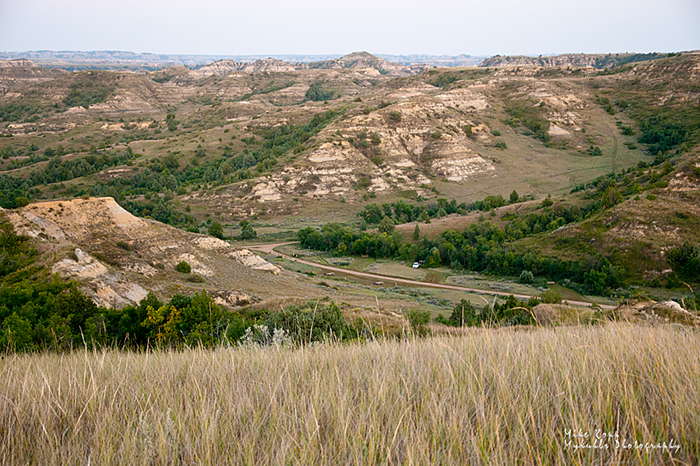
Between the rancher’s fence lines is what used to be an active road, a section line road laid out on every section on one-mile grids. Most are no longer accessible or visible.


TR’s Elkhorn Ranch is easy, but not always.

Undeveloped historic site, the Elkhorn Ranch.

Teddy Roosevelt’s backyard at the Elkhorn Ranch. The house stood on the foundation blocks which are all that’s left of his ranch home

Off the beaten path – it’s exactly where Teddy Roosevelt wanted to be in 1883 – and so the Elkhorn ranch became his refuge. He’d just suffered a string of losses, including the deaths of his wife and his mother.  To get his life back on track he went where others have gone for more than 100 years – and you can go there too, if you’re willing to get off the beaten path.

Teddy Roosevelt in his buckskins as a  Badlands rancher

About 20 years before he became the 26th U.S. President, Roosevelt lived the life of a wilderness rancher.

To find the healing place TR called home for many years, you’ll travel more than 25 miles of gravel road through wilderness ranch area.  It’s a place of few people and many miles.  “The lives of such places were strangely cut off from the outside world,” TR wrote. “The whole region is one vast grazing country.”

To the ear, there is a great amount of peacefulness, but that does not mean quiet. Birds carry on loud conversations, particularly in the early morning and evening.  The wind itself is a sound that travels the musical octaves. In the evening, it’s the melody of the coyotes’ songs you’ll hear.

To the eye, distance and color become a stimulating visual entertainment.  When you think you can see no further in the distance, the next hill-top will unveil further horizons.  When you think you know what green looks like you’ll find more variations in the landscape – or in the autumn, brown takes on a rainbow of variations.

Teddy Roosevelt raised cattle, hunted and lived in these hills surrounding his Elkhorn Ranch

Teddy Roosevelt raised cattle, hunted and lived in these hills surrounding his Elkhorn Ranch.  A thin red ribbon shows the road to his ranch.

The Elkhorn Ranch site is a national treasure, undeveloped and barely marked. We needed a good map to find it; the U.S. Forest Service map is perfect for a search like this.  After a bit, we began to recognize the repeated Elkhorn sign posts directing us further down the road.

It's easy to get lost in the Badlands, if it were not for road signs like these, including the one to the TR ranch

The small sign with an Elkhorn icon indicates the way to the ranch.

The campground up the road from the Elkhorn Ranch site offers a bit of protection from the hot Badlands sun.  Tent camping is more than sufficient with the campground’s supply of water, firewood, and privacy.  Even though, we were in a public campground, it was still much like getting away from it all. In fact, one night, there were only two other campers in the campground.

To really get away from it all, a short hike up the hill to the north gave us a glimpse of the road we’d follow to get to the campground. The red scoria road winds down through the bottom ground trees to the clearing where Roosevelt set up his ranch.

The scoria road to the national landmark of Teddy Roosevelt's Elkhorn Ranch.

The scoria road to the national landmark of Teddy Roosevelt’s Elkhorn Ranch.

The Elkhorn Ranch site is undeveloped, so it will exercise your imagination skills to envision what it was like 150 years ago.

“Just in front of the ranch veranda is a line of old cottonwoods that shade it during the fierce heats of summer, rendering it always cool and pleasant.  But a few feet beyond these trees comes the cut-off bank of the (Little Missouri) river. … The shallow stream winds as if lost.”

— from Ranch Life and the Hunting Trail by Theodore Roosevelt 

elkhornranch


The Little Missouri River is a wilderness through-route today, just as it was for Roosevelt.  It is a challenge to canoe or kayak, and the spring seems to be the best time to attempt a float, but it’s always a beautiful walk through the Badlands where Roosevelt ranched.

The Little Missouri River in front of the Elkhorn Ranch house.

The Little Missouri River in front of the Elkhorn Ranch house.

“The stream twists down through the valley in long sweeps, leaving oval wooded bottoms, first on one side and then on the other; and in an open glade among the thick-growing timer stands the long, low house of hewn logs.”

— from Ranch Life and the Hunting Trail by Theodore Roosevelt 

We have hiked, canoed and driven the Little Missouri River as it flows northward from Wyoming and Montana to the confluence near Williston, North Dakota.  It’s a pleasant and non-stressful hike to follow its river banks. It’s easy to see why Roosevelt wrote often and vividly of the river.  We recommend hiking the river trails near the ranch.  Hiking the hills, bluffs and buttes above the Elkhorn is a minimal challenge to anyone is good condition and who has hiked some of the rougher terrains further downstream.(See the post on hiking the Long X Trail along the Little Missouri River — http://wp.me/pOdPo-Gi ).

Elkhorn campground sgntre

The Elkhorn Ranch campground offers shade next to the trees — a rare luxury in the nearly tree-less Badlands. The white dot along the campground road is my pickup at our campsite.

While the riverbank hike is enjoyable and calming, it’s the views from top that exhilarate.  Not only are the views mind-numbingly expansive, but there’s a sense of accomplishment from having hiked to the top of what appears to be an unpassable slope.  The key is “switchbacks.” It’s wise to never get in a hurry when heading up to higher ground – don’t attempt to go straight up.  Follow gentle rises back and forth across the face of the hillside, pausing to not only catch your breath, but to scope out the next set of switchbacks to take you to the next level.

Once at the top, you can see why Roosevelt lived here. He built his stamina and his skill at strategic thinking.  You can get a sense of the challenges he faced as an Easterner turned rancher.  When picking a trail for his cattle, or just for himself to get to Medora or Dickinson, Roosevelt planned his route. It was not easy to get any where.  He wrote, “The course outlies across great grassy plateaus, along knife-like ridge crests, among winding valleys and ravines, and over acres of barren, sun-scorched buttes.”

The Elkhorn ranch area is undeveloped and perhaps that’s best. It gives a visitor a chance to see Roosevelt’s nature as it was when he was here, an experience that prompted him to establish conservation measures and advance the national park system. Thanks to his time in these valleys and hills, Theodore Roosevelt became “the conservation president,” and doubled the number of sites within the National Park system. As President from 1901 to 1909, he signed legislation establishing five new national parks.

For the day-visitor it’s a moment of spiritual rest, visual stimulation, and a sense of accomplishment when you climb a hill, turn, and look back at how far you’ve come – a good life lesson.

What would it take to make you want to check out the site — accessibility, directions, time?

Elkhorn hills

The Elkhorn ranch trip is part of the exploration of Beautiful Bakken.

https://www.facebook.com/beautifulbakken

www.beautifulbakken.com

A Sunday stroll up Chimney Butte

It doesn't look like a chimney, but that's what it is called, "Chimney Butte."

It doesn’t look like a chimney, but that’s what it is called: “Chimney Butte.”

It’s been called “Chimney Butte” for more than 200 years, but I’m not sure why; it doesn’t look like a smokestack.  Lewis and Clark used it as one of their markers when they trekked the Missouri River a few miles north.  You can find it between Mandaree and Keane between Highways 22 and 23 in McKenzie County.

The McKenzie County road past Chimney Butte is well-maintained and an easy drive.

The McKenzie County road past Chimney Butte is well-maintained and an easy drive.

It was our target for the Sunday hike because for one reason, it’s public-access land.  We didn’t have much time because the sunshine we’d enjoyed all day disappeared; rain clouds moved in at the same time we parked along the road on the south side of the butte — a well-maintained road.

We’ve been adding to our Beautiful Bakken Facebook page and thought this Sunday photo hike would help add to the collection of images displaying the beauty of the Badlands, the Bakken oil field.


Here’s the address –https://www.facebook.com/beautifulbakken

and our gallery of Beautiful Bakken photos on our website at this address —

http://www.mykuhls.com/Beautiful-Bakken/

Rain approaching from the southwest gave us a sense of urgency.

Rain approaching from the southwest gave us a sense of urgency.

We packed only our cameras and something to drink, then crossed the prairie and up the slope toward the base of the rocks. There, we stopped long enough to survey the incoming rain behind us to the south.

Chimney butte wildflowers
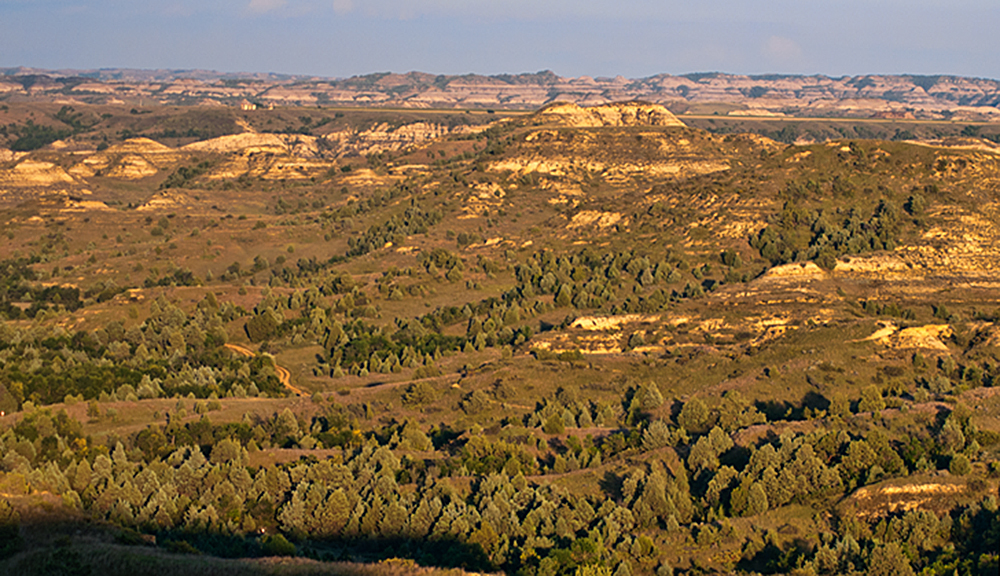
Our mission was to photograph a seasonal transition,  capturing the change from early spring’s dormant brown to the more lively green.  A few hints of spring met us along the slope such as the wildflowers sprouting ahead of the green grass.

Once at the base of the rocks, we followed the grass line around to the opposite side where we could more easily follow a switchback to the top.

At our destination, the top, we could survey the entire region of the heart of the Bakken Oil Field, eastern McKenzie County and western Mountrail County.  To the east Chimney Butte’s partner, Table Butte invited us to hike and climb to the top, but we declined. It’s private property and we thought we’d first get the rancher’s permission to climb Table Butte.

Table Butte looks more like a table than Chimney Butte looks like a chimney.

Table Butte to the east looks more like a table than Chimney Butte looks like a chimney.

While at the top, we could see where we’d started and there, a mile or so away, was whatMike shoots from Chimney Butte copy Chimney butte mare and coltlooked like dogs running across the region.  I used my telephoto (as low-power as it is) to try to get a better glimpse. It wasn’t dogs, it was a pair of colts.  I zoomed in on one when it ran back to its mother at water’s edge.

After resting a bit, we hiked back down the easy side.  It would have been faster to go down the rock side, but that would mean a jump of 70 or 80 feet.

At the bottom, we hiked back across the grassland base.  Over the hill, a different sign of spring watched us — a mare and her colt. This was not the same ones we had watched when we were up on top.white mare black colt appear over the hill

white mare black colt walk by in the trees sig
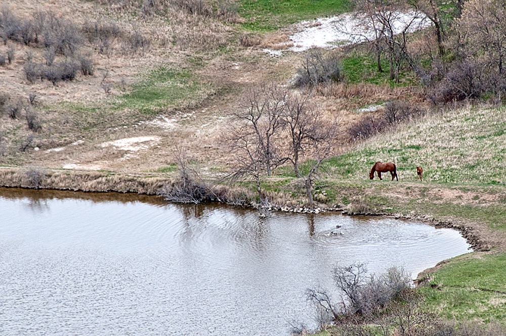
We stopped to see if the white mare and black cold would get closer. We were between them and the water — their apparent goal.  Mom chimney butte white mare black coltprotected her babe, so they skirted around us. We stopped, watched and photographed their patient easy stroll past us.   They disappeared over the hill.


Oh, and those first two colts we spotted?  They had moved on, but not far. We looked around for them, but they were safely out of sight. We got back in to our pickup and drove around Chimney Butte to the east side.  There they were! The mares and their colts didn’t mind us driving by. We stopped long enough to grab a shot or two of spring’s new life.two colts and a mare on a hillside

two colts


two mares two coltsWe’d met our goal. We’d captured signs of spring in the beautiful Bakken region of North Dakota where nature underground is yielding a harvest of plenty and where nature above the ground displays the beauty we’ve come to see.

https://www.facebook.com/beautifulbakken

http://www.mykuhls.com/Beautiful-Bakken/

Horse Play

Eye contact!

Eye contact!

Be observant.

Be ready.

I was halfway there.  I was observant, but not necessarily ready.

One afternoon, I’d gone out to shoot stock photos of the energy industry activity in western North Dakota.  I was west of Dickinson shooting long shots of an oil refinery under construction.  It was a grey sunless day. The diffused light dampened the contrast and color.  So, I didn’t waste much time or effort to shoot grey, lifeless photos of a construction project.  I turned around on the gravel road and headed back to Highway 10.  Then I saw it: life!

An appaloosa dances while the rest of the herd watches

An appaloosa dances while the rest of the herd watches

Across the road, a herd of horses horsed around. Horse play!  And wow, they were playing!

App dances, white walks away wtrmrkScampering!

Frolicking!

Two appaloosas and a white or albino took turns dancing, jumping, running.  It was like watching kittens or puppies play. Entertaining and joyful.  Their antics were captivating; I forgot  camera settings.

three horses play wtrmrkObservant, I’d caught the action before I drove past, but I wasn’t quite ready.  My camera was still set for the dark images of the construction site.  I stepped outside my pickup and shot. Adjusting the camera between shots just a bit at a time, I monitored the playground to see how these playful critters scooted about.

White and App kick and run

I’m sure the gaiety lasted longer than my short time allowed.  I could have sat for hours to watch the merriment – but alas, I was supposed to be “on the job.”  I had appointments to keep. So, discipline topped enjoyment.  I left the herd in revelry while I headed off to responsibility.  Now, I’m home, I see that why I was mesmerized by the play.  So, I posted the set of images on my website. http://tinyurl.com/pztlyx4

How long would you have stayed to watch?

Sure it’s cold, but….

December's subzero temps and snow

December’s subzero temps and snow

Yeah, there’s a lotta snow out there. Yeah, there’s a minus sign in front of the temperature. That means the annual self-imposed illness called “cabin-fever” is about to set in, but only if you choose to let it.  I choose not to let it set in. That’s why I look for ways to get out of the cabin, and the annual Blue Collar Cafe art shows are one way to do it.  The first one is Thursday, December 5.

1397648_558096930949712_1831312918_o

I started getting ready for the show back in October.  I’ve found a photographic niche, nostalgic romantic images of North Dakota history.  That includes a farmstead long abandoned with an unused Ford pickup parked in the front yard.

Oliver County Farm in barn board frame I made

Oliver County Farm in barn board frame I made

Or a farmstead on the edge of a growing pothole, water lapping at the doorstep.

Sheridan County abandoned farmstead about to be overtaken by growing pothole.

Sheridan County abandoned farmstead about to be overtaken by growing pothole.

I’ve found antique cars such as this 1941 Ford Tudor Deluxe parked in a pasture in northern Burleigh County.Old Fordt wtrmrk Mike shoots old Ford

They’re part of my collection of images headed to the Blue Collar Art Show and Soiree.  The Blue Collar Cafe on Airport Road across the tracks from Krolls Kitchen hosts monthly art shows beginning in December, and I’ve been pleased and honored to be a part of the shows.  The owner, Jerod Hawk advised me to come in with larger pieces than what someone at home could print out from their computer.  So, I have. These are as large as 2’x3′ framed images.

A few images for blue collar show

Late at night I’ve worked in my wood shop, turning old barn siding in to frames for my images. The wood is from a 105 year old barn between Anamoose and Goodrich that blew down about 5 years ago.  I maintain all its color and character.  The texture, the warp and the bends in the wood makes it a challenge to create a straight and square build, but it gives each frame its unique style and color.

Selecting the right piece of wood for a frame

Selecting the right piece of wood for a frame

On many snowy winter nights, you’ll find me in my wood shop sorting and selecting the wood, matching its dimension, color and grain for both the inner frame and outer border (making it two frames, one inner and one outer)  to create as uniform appearance for each frame, yet different from every other one.1201131859

A few of the images I’m taking back to this show were quite popular at last year’s Blue Collar art shows, that includes this one of the Pettibone Brain Company. (No that’s not a typo. The private owner climbed up there after he bought the structure and turned the “g” in to a “b” to make the word “brain.”)

Pettibone "Brain" Elevator

Pettibone “Brain” Elevator

This year’s Blue Collar art shows are bigger than last year’s first shows.  The floor space is more than double from the original space and there will be twice as many artists. I’m blessed to be one of them.

October 22 moody images

Pontiac under the moon in the weeds

In this set of photos, my goal was to capture the mood rather than the image as a snapshot.  The Pontiac under the moon is one of my more complimented images.  I think it would work well as one of a series of notecards. What do you think?

You can see the moon barely visible just above the front left corner of the car in the trees.  It was another one of those hazy, overcast fall afternoons. My goal that day was not to photograph the car.  In fact, it was an after thought. My goal was another set of images of the old Wilton Coal Mine entrance — again here stylized to represent the surreal and even “spooky” mood of that area.

Wilton Coal Mine entrance

Photoshop filters enhanced the natural light and glow of the golden hour to create that warm surreal effect.  In the photo of the coal mine entrance, can you spot the full moon? It’s just above the horizon next to the mine entrance, between it and the tree on the horizon.

This scene is just east of Wilton about a mile.  It captures my imagination every time I see it or visit it because of the old stories I’ve read about life during the mine’s peak — a time when this region of the United States was in its infancy and growing quickly.

Moon glow

Scattered around the pasture are other reminders of days gone by including the old Pontiac.  In a few days I think I’ll have to return to capture more of the imagery, but most capture more of the mood of the region.  The full moon rising only added to the surreal spooky atmosphere.

I dunno. How do you present an image with its natural “feel” by merely pressing the shutter release on a camera.  I believe some crafty artwork applied post processing helps tell the story.

September 22

beside still waters

A sight not often seen in North Dakota — sheep on a hillside.  In fact, I can more quickly show you herds of domestically produced elk than I can flocks of sheep.   Even just down the road from this flock of sheep is an elk herd that I’ve attempted to photograph but have been unsuccessful.   In fact, every one of our neighboring states raise more sheep than does North Dakota.  Wyoming, South Dakota (4x),  Montana (3x) and Minnesota (2x) all out-produce North Dakota.

Yet between Wilton and Mercer is one flock of sheep that keeps the pasture tamed of most noxious weeds.  The sheep graze freely near an abundant water source, and I’m reminded of Psalm 23, “He leadeth me beside still waters.”

It was an overcast day when I shot this, the sun somewhere behind me which gave me about as good of light as I would get on this cloudy day.  It provided good even lighting with only natural color contrast and very few shadows.

July 29

Buffalo berries along the road

It’s that time of year when the green of the prairie is marked by the red of the berries.  The buffalo berries pop out in mid July giving a bit of contrast to the regions.  The strong, but scrawny and scratchy bush is a solid windbreak most of the year, but it’s this time of year when it bears fruit to add to the color and food supplies of the region.

Plentiful in the badlands and west river, these buffalo berries stand along a gravel road near Washburn.  I wasn’t sure what I’d be shooting for my 1-a-day project, but when I topped the hill, I knew these marks of North Dakota were the day’s entry.

July 27

North Dakota's rolling prairies

Today’s blog entry has two purposes.  One is to once again demonstrate that North Dakota isn’t as flat and feature-less as some believe.  It’s not as barren and colorless as some would believe. The green, even in the end of July is omnipresent.

Toward dusk on this July afternoon/evening I headed north of Wilton toward McLean County.  Only about 3 miles north of town, the landscape drops down below and a panorama of the green fields and pastures unfolds.

Next to the road, the contrast of two fields, one a small grain field, the other a pasture/hay field demonstrate some of the colors of North Dakota.

I mentioned at the top that there were two purposes to this blog. The second is to set up for your view similar images that I fooled with in a playful artistic moment, using filters, plug-ins and of course trusty reliable Photoshop CS 3, I gave these images a bit of a different look.

Which do you prefer?

July 23

Southwest North Dakota

Go back to the July 5 entry in North Dakota 365 and compare it to this image.

This is the opposite side of the state.  I’m standing on a hill south of South Heart, North Dakota, along the road to show that THIS is what most of North Dakota looks like. The gentle rolling hills, the variegated green of the landscape and the wide open view of a storm passing to the east is what most of the state looks like outside of the Red River Valley.

On this particular day, I was in the western part of the state of an event I thought I was going to shoot.  The event was all weekend long and turned out to pretty much be a bust.  So, I drove gravel roads that allowed me to penetrate the vast unpopulated region of southwestern North Dakota.

I actually had intended to go further south and east in to the white butte region of the state, but my gas gauge limited my enthusiasm.  It was at about this point I realized I needed to head back to civilization to fuel up or I’d be out here forever.

I had meandered my way to this location without marking my route. And as you can guess, there are few if any directional signs or street signs to guide you to where you want to go.

Since I had been looking for photo ops, I had visually studied the landscape and traced my route backwards from where I had started at South Heart.  It was a good thing I did, too because when I got back to Dickinson, I was down to the last gallon of gas in my tank.  I suppose a GPS might be a good thing to have if I were to do this often.  But in all my hiking, hunting and backpacking days, I’ve never gotten lost yet.  So, to depend on a GPS is like depending on an electronic calculator when you’ve sharpened your mental abilities to do complex calculations in your head.  Do you need a GPS?